Tag Archives: Mapping

B Company 329th IR HQ Positions During Normandy Campaign July 1944

For B Co, 329 IR we start off with comments and then nothing. Looks like there was a change in who was doing the Morning Reports.  But we do have good position references for the whole month of July 1944.

329th Infantry Regiment, Company B HQ positions from 1 July through 30 July 1944, Normandy France

329 IR, Co B HQ positions, 1 July through 30 July 1944

E Company 330th IR HQ Positions During Normandy Campaign July 1944

I recently had a very nice note from someone whose father was in E Co 330 IR during July and August, 1944.  So I thought, I don’t necessarily have to go from A to M, 329 to 331.  So here is E Co. 330 IR, July, 1944.

I had an pleasantly different problem here with E Co. 330 IR. Whoever was doing the Morning Reports took full and ample advantage of the Record of Events.  I had trouble making it all fit without cluttering up the map.  Not sure I succeeded, but you have to appreciate the recorder’s willingness to take the time to do good Records of Events.

I only have doubts about a couple of entries.  14 July says they “marched 2 miles toward the front-line”, but then the night’s position is neither 2 miles away nor necessarily toward the front, at least not what we might think of as the front with our vision of the operation.  But doesn’t mean they didn’t move toward the fighting.  Later with all the companies mapped out, maybe it will make more sense.

Then for 19 July, the report says “moved back one (1) mile”, and while it really was an actual good mile, it wasn’t “back” by our perspective, but forward; which might explain why they were disappointed to be receiving more artillery fire instead of less.

By the way, anyone can feel free to point out typos, misspellings, etc. Such thing’s never have been a strong point.

E Co, 330 IR HQ positions during the Normandy campaign; Normandy, France; July 1945

E Co, 330 IR HQ positions during the Normandy campaign; Normandy, France; July 1944

Position of 1 Bn, 330 IR from 28 July to 31 July, 1944, around le Lorey

I had someone interested in seeing just when, what units of the 83 ID were where, around le Lorey. This seemed like an interesting way to look at things.  Once I had it done though, I thought that a day by day visualization would be less busy, easier to follow; but then I thought again, what was wanted, was to see where everything was around a certain point and what I had worked well for that. An operations view could be done later, once I have all the companies mapped out individually.

We are dealing with the 1 Bn, 330 IR here, on the days 28-31 July, around le Lorey. This is the ending of the Normandy campaign for these guys and they are being blessed with rest, hot food and recuperation.

I had trouble only with D Co coordinates for 28 July. The report used the same coordinates as the days before, up to the north-west of Remilly-Sur-Lozon; but it specifically said in the location field for 28 July, that they were “2 mi S Remilly-Sur-Lozon”; and in the Action Report for the 28th it is stated they advanced a good 5 miles; and in the Action Report for the 29th, it is said they remained “in defensive position”, no mention of any movement. So, I have assumed the recorder made the mistake of putting the position at beginning-of-day instead of at end-of-day for the 28th and have placed the 28th where the 29th was reported. I think that’s a pretty good guess. 

Position of 1 BN, 330 IR, around le Lorey, France from 28-31 July, 1044

Position of 1 BN, 330 IR, around le Lorey, France from 28-31 July, 1044

A Company, 229th IR HQ Positions During Normandy Campaign

I finally got another company campaign map done.  I decided to go back to A Co, 329 IR and should follow along in order.  A Co, unfortunately doesn’t have much in the way of action reports, but we do get a good picture of their positions and moments. I have serious doubts about days 17 and 18 because the given coordinates puts A Co on the other side of highway 3, as it was called then, which I thought was in the 4 ID area by those dates.  But if the coordinates given were wrong, the author was insistent; using the coordinate for each day twice in the report. So I quite trying to figure out what might have happened and placed the points as given.

A Co, 320 IR HQ positions during the Normandy campaign; Normandy, France; July 1945

A Co, 320 IR HQ positions during the Normandy campaign; Normandy, France; July 1945

15 July, 1944, 16:00 1st & 3rd Bn Progress against Remily-sur-Lozon

So now we come to the final overlay in my possession.  We saw the objectives for the day for the 1st and 3rd Bn, 330 IR, July 15th.  Here we have progress as of 16:00.

I thought with this nice display of company positions this overlay deserved a zoom-in. So I cropped the full overlay and included it below the first.

15-July_1bn-3bn_Progress_a

July 15, 1944, 16:00 Progress of 1st & 3 Bn against Remily-sur-Lozon

15-July_1bn-3bn_Progress_b

July 15, 1944, 16:00 Progress of 1st & 3 Bn against Remily-sur-Lozon

15 July 1944, 330 Infantry Regiment, Objectives for 1st and 3rd Battalions

Ya, I know, big delays.  Sorry. We’ve been on the move again and with threats of having to move the big tent. Fortunately, for now, the big tent stays put, otherwise I’d be out of touch for a lot longer.

Here we have the first of two overlays for 15 July.  I had thought this one was the last, but I see that there is one more that I had thought was just a detail from this one, but I see it has new information, so we’ll be doing it as well.

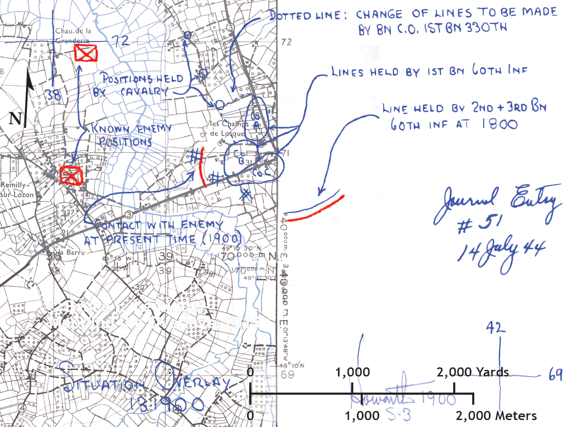
This covers the day’s objectives for 1st and 3rd battalions; 2nd is detached and back around Sainteny. The 33o IR has been attached to 9 ID.  We can see this was what was being set up on 14 July. We are a good deal to the south and east, essentially swinging around to the rear of the le Port–le Isle / Tribehou causeway; good news for the 330th. As you can see, we are way off the map again; but all 330 IR information is on-map, so I think I’ll leave it be. Really, guys, the work it takes to geo-reference another sheet and, more importantly, stitch it to this one, isn’t worth our immediate needs.

Now, having circumvented one marsh, the 1st & 3rd Bns, 330 IR, had to cross another—thankfully smaller—along the le Lozon river, attacking toward Remilly-Sur-Lozon on one of those peninsulas formed by the flooded wet lands of Normandy. The circular areas labeled P, Q, O, S, & T are 330 Bn objectives with R1 being the immediate objective for 3 Bn and R1 for 1 Bn. The 60th IR, 9 ID, would be on their left with objectives being M, H, & N.

To orient yourself, Tribehou, which we’ve seen before being in the lower right-hand corner of some of the overlays, is now in the upper right-hand corner of this one. La Varde, which we’ve also mentioned before, is in the upper left-hand corner. Remilly-sur-Lozon is more or less right in the middle, inside the “O” objective.

15 July 1944, 330 IR, 1 & 3 Bns Objectives

15 July 1944, 330 Infantry Regiment, Objectives for 1st and 3rd Battalions

13 July 1700, 1Bn 330 IR, Definition of New Positions Near les-Champs-de-Losque

This third to last overlay for 13 July suddenly jumps further south and east.  So we are off the map.  If this continues I’ll have to dig up the map sheets to the east of what I’ve got; if not, I’ll just let it go since the 83 ID related information on this overlay is still on the map. This overlay was the one that made me realize that the date given for Journal entry wasn’t necessarily the date of the situation as drawn on the overlay.  What has become obvious is a person making a journal entry is, in a way, creating a narrative.  So if an overlay from the day before furthers that narrative then it is included.  The problem is when the only date on the overlay is a journal date.  Then we’ll have to depend on the sequence and information in the reports to establish the date, or just guess. I also see now I could use the information from the journal to illustrate each day in a single post including the “n0n-overlay” information to better explain the overlays.  I might just do that once I finish all the overlays I have (just a few more now, actually).

So, here we have an overlay drawn up to show the position of  1 Bn, 9 ID near les-Champs-de-Losque.  It could very well have been drawn up in the 14 July since its purpose is to establish where the right flank is for 13 July. The right flank position is needed so 330 IR, minus 2 Bn, can move there on 14 July; being attached to 9 ID for a couple of days. What you notice is this maneuver should save them from having to make an assault across the Taute river march using the le-Port to Tribehou causeway. The progress of 9 ID has essentially outflanked the German positions there.

13 July 1900 1Bn Move to North of los Champs-de-Losque

13 July 1900 1Bn Move to North of los Champs-de-Losque

13 July 1400 330 IR 01 Bn Position & State of Taute River Bridges

Another 13 July overlay.  This one some time around 1400.  I’m not sure because there are two times on the overlay.  I suspect one is the time made and the other the time received by S-3?  We get the positions of 01 Bn. companies A, B & C.  Nice!  A note about the state of the bridges over the Taute River and one of it’s tributaries and a comment about “flushing” the area.  I suppose flush us used here as when one is hunting: “to flush out”?


13 July 1400 1044, State of Bridges over Taute River in 1 Bn. 330 IR area.

13 July 1400 1044, State of Bridge over Taute River in 1 Bn. 330 IR area.

12 July 330rd Infantry Regiment, 3rd Battalion, Patrol Area

Still on 12th of July, 1944.  This overlay obviously was made early morning since it seems to be a planning document for the 3rd Bn, 330 IR to patrol the left flank of the regiment—and division, actually.  This one took me awhile to decide how to do since Lt. Notbohn decided to use more colors than I’d anticipated when I set out my methodology for transforming these overlays. Then the road net trace and the terrain trace just wouldn’t line up and in the end I decided that had to be because they weren’t drawn lining up; after all lining things up wasn’t really necessary for the guys making these overlays as long as the intent was clear.

12 July 1944 Patrols for 3rd Bn mopping up

12 July 1944 Patrols for 3rd Bn mopping up

12 July 330 Infantry Regiment Outpost Plan

Still on 12 July, I assume end of day, we have a regimental plan for outposts on the 83rd’s side of the Taute River and marsh. This would seem to indicate a pretty good advance on the 12th then.  We will see once we get to the various reports.  What this shows is that the 330th IR is occupying a line on the north side of the marsh anchored from the south to the north-east from Le Moulin through Le Port and St. Andre de Bohon to Manior. Across the marsh (and the river Taute) were two causeways; one from Le Moulin to La Varde, and one from Le Port to Tribehou.  The next battle would be to get across these.

12 July 1944 330 Infantry Regiment 83 Infantry Division Outpost Plan

12 July 1944 330 IR 83 ID Outpost Plan